How to go about getting your own private water supply…
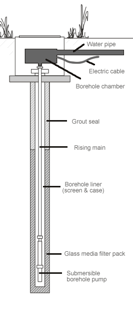
 Firstly is the site suitable for a borehole is there enough space away from possible contaminants such as cess-pits, roads and other dwellings or industries. The next stage is to obtain consent to drill from the environment agency for water abstraction. A test borehole needs to be drilled to establish water quality, the depth of the water surface and the volume of water in the well. Additionally the borehole is lined with a casing and a pump selected and fitted possibly with water treatment if required.
Finding a suitable borehole well location
There are many scientifically proven techniques to best locate a position for the drilling of a borehole. Much controversy exist in the ground water industry over which method is the best, although not one single method currently exist that can, with 100% accuracy, indicate the exact depths and volumes of ground water occurrence.
There is however scientific methods that can, with the correct application, increase the chances for successfully locating borehole sites. The following factors are taken into consideration in ground water exploration. Firstly one has look at the geological setting of the area I.e. the types of geological formations present in an area, as well as the potential of these formations to act as aquifers. Secondly one has to look at hydrological factors such as rainfall and the percentage that contributes to groundwater recharge, as well as the water balance for a specific catchment area.
Typical questions that are asked in a groundwater investigation are: how much do we need? Can the aquifers provide in this need?, is the ground water quality suitable for the intended use? Etc. To answer such questions it is necessary to study available information such as geological and hydrogeological maps, aerial photographs, satellite images, borehole information, such as borehole depths, yields, depths at which water was intersected, water quality intersected, of all, or as many as possible of the boreholes in the area.
We list five of the most commonly used geophysical methods applied to identify positions for borehole drilling. The essence of these techniques is based on the understanding of the geological sequences present in the area, and none of these techniques can be used in isolation.
Magnetic method. This is probably one of the most commonly used geophysical surveys that are used to assist with the location of positions to drill boreholes. This method measures the changes in the normal magnetic field of the earth, and it is used to pick up contacts between different geological formations such as dolerite dykes.
Electrical resistivity. With this method an electrical current is passed through the underlying rock and the difference in the passing of this electrical current is through the different rock formations is measured. The differences in the resistivities of rock types can measured, which can then be correlated to water bearing zones.
Electromagnetic method. This method uses the difference in electromagnetic conducting abilities of rocks and is related to the electrical resistivity method.
Gravimetric method. This method is based on the earth’s gravitational field, caused as a result of the different densities and mass of rock formations, are determined at different measurement points on the earth surface this method has a probably of a 70/30 chance (depending on the area) of drilling a successful borehole.
